
I've always kinda wondered, anyone know just how many acres the whole AirVenture site occupies? Not counting parking lots and runways?


I've always kinda wondered, anyone know just how many acres the whole AirVenture site occupies? Not counting parking lots and runways?
"Don't believe everything you see or read on the internet" - Abraham Lincoln


This might help, WISCONSIN STATEWIDE PARCEL MAP
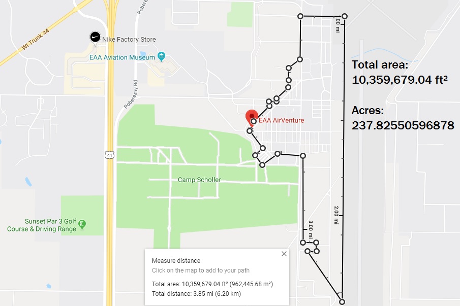
Total area: 10,359,679.04 ft² = 237.82550596878 Acres
The area is petty much where people would be walking during the show.
Not sure if that is what you were looking for?
Cool. Thanks for the info - Us city slickers are hard pressed to convert space into land acreage - lol
"Don't believe everything you see or read on the internet" - Abraham Lincoln
That area is partly made of Winnebago county land and some EAA land. Also all of Scholler is EAA land as well, as well as all the land around the museum. If you want to explore this is a great link to figure out who owns what in the parcel viewer.
https://www.co.winnebago.wi.us/planning-and-zoning/gis
Last edited by krw920; 08-12-2019 at 03:22 PM.
Not really interested in who owns what land parcel, more just seeking a figure to use describing the event in terms of how many acres of airplanes and airplane people comprise the average AirVenture.
"Don't believe everything you see or read on the internet" - Abraham Lincoln
Given that Wrongway only gave you the show grounds, add another 500 acres for Scholler.Originally Posted by CHICAGORANDY

google earth allows you to measure areas. Click on the "ruler" in the tool bar, and then select :polygon". Select your units of measurement and go at it. Pretty straight forward.
Minnesota

You could visualize, or measure this way. 1 acre is 43,560 Sq ft. or 66 ft by 660 ft. or 208.71 ft by 208.71 ft. I expect to see a lot of people with tape measures next year !
Bob
Thanks for the Google Earth mini tutorial Kim. Looks like counting in the Musuem, North and South 40 areas AirVenture is 'about' 1500 acres all in.
I've never used Earth for more than visual sightseeing before. Nice to see what the tools can yield - lol
"Don't believe everything you see or read on the internet" - Abraham Lincoln
 Posting Permissions

 Reply With Quote