
Sorry about that. Try this:Originally Posted by martymayes

http://www.wanttaja.com/icon.pdf
Ron Wanttaja


Sorry about that. Try this:
http://www.wanttaja.com/icon.pdf
Ron Wanttaja

This is a bit much. The Icon has recording crap on it, so it wasn't that big of a mystery. And I think impugning the integrity of the inspectors is pretty low in any case.
I guess the photos we got of the wreck don't show how short that canyon is, as I'd of thought he could dump the throttle, crank the flaps, and land on the water.
The opinions and statements of this poster are largely based on facts and portray a possible version of the actual events.
The NTSB full docket has a bunch of photos, including Google Earth images of the canyon. The cove portion of the canyon is about ~1/2 mile long, the accident occurred at nearly its end. The cove is basically a funnel; the hills on the side get closer as one nears the end of the cove.
The pilot probably didn't have long to decide that he was in trouble. Most of us, I think, try to fly out of trouble...plopping down for a quick landing may not have immediately occurred to him; he was probably focused on turning around and flying out. The aircraft was equipped with a BRS, and there was no apparent attempt to pull the handle. However, at the altitude the plane was flying, it wouldn't have helped.
You can access the full docket by going to...
https://dms.ntsb.gov/pubdms/search/
...and entering WPR17FA101 as the accident number. Lots of pictures, and full witness statements.
Ron Wanttaja
One of the items on the full docket is the output from the onboard data recorder. Here are my impressions, looking at the data. Keep in mind I've never looked at this sort of thing before.
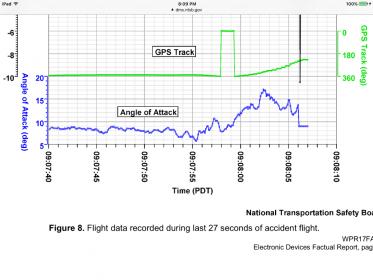
All times are in minutes and seconds (m:ss), and are from the "Minutes" and "Seconds" column in the output (rather than the "Time (PDT)" output, which is about 4 seconds faster), heading is from the GPS track. Throttle setting is apparently percentage of travel (0-100%). Airspeed is labeled as "Indicated Airspeed", apparently not from GPS.
m:ss
6:41: Aircraft on roughly west heading, starts turn to the North. Airspeed 62 knots, GPS height 450 feet (I'm assuming this is MSL). Throttle 65%
6:51: Turn to north completed, base heading is about 355 degrees. Airspeed, altitude roughly the same. Throttle increases slightly, to 72%.
7:42: (~50 seconds later) Throttle starts to increase, aircraft starts to climb. Heading has been varying slightly, probably following the cove.
7:52: (10 seconds later) Throttle now at 100%, climb continues. Starts ~10 degree turn to the right.
7:56: Starts to turn left. Altitude is 490 feet, airspeed 55 knots
7:58: Minimum airspeed, 49.6 knots. Altitude 500 feet. Heading 345 degrees
8:01: Altitude 500 feet, starts to drop
8:02: Apparent impact. One second prior, vertical G-loading was 1.3Gs, increased to 1.79 Gs prior to initial impact (7.49 Gs...remember, this is VERTICAL only). GPS height 470 feet. 09:08:06 PST.
8:03: Last full sample. Altitude was ~445 feet.
Airspeed just prior to impact was 66 knots, throttle had decreased to about 30%. We don't know if this is real, or some sort of glitch in the data.
Ron Wanttaja
Does the dirt tracks and other evidence indicate a forward impact? Or stall spin vertical impact?
I'm feeling dim this evening - my search keeps coming up no records found?
Assuming you're referring to the Docket search feature. You might be missing/adding characters in the NTSB number when you enter it.
However, there IS a odd human-factors problems with the search function. Enter the NTSB number for the NTSB Accident ID, but do NOT hit the very obvious "Search" button. On the right side just above the data-entry box is a "Find" button...hit that, instead. Then click the NTSB Number under "Search Results."
Ron Wanttaja

Here is the direct link.
Looks like angle of attack went to 17° in last 5 seconds. The right wing impact trench I guess suggests a vertical impact.
Last edited by Bill Berson; 08-09-2017 at 09:21 PM.
Thanks for the link - an interesting report - also I am impressed with how thorough and detailed the investigation was. I'd never read an NTSB report before.
 Posting Permissions

 Reply With Quote