


See the link below? I just read about these for the first time. Are any of them still out there?? Has anyone ever seen them from the air?
http://www.snopes.com/travel/airline/arrows.asp
Don


See the link below? I just read about these for the first time. Are any of them still out there?? Has anyone ever seen them from the air?
http://www.snopes.com/travel/airline/arrows.asp
Don
Check out this blog post from Chapter 936 in Utah: http://eaachapter936.blogspot.com/20...te-arrows.html
There are some aerial photos, and also a more complete history than the blurb in the Snopes article.
I love aviation artifacts like this; thank you for posting.

Wonderful stuff. Now here's a project...I wonder if it would be possible to find a comprehensive list of each and every one of these sites with the latitude and longitude? It would be great fun to put that up on a web site and have pilots send in photos of each one as it looks today, kind of like GPS cache hunting from the air. The link above gives the coordinates for three of them...here's a link to one on Google Maps. I bet there are many that have been caught up by development but might still be visible in outline from the air under the lawn or something like that. There must have been little houses for the folks that maintained the generators and lights...I bet some are now private homes, like old lighthouses.
*******
Matthew Long, Editor
cluttonfred.info
A site for builders, owners and fans of Eric Clutton's FRED
and other safe, simple, affordable homebuilt aircraft

Here's a similar thing that is really strange: giant concrete crosses in the desert, used to calibrate Corona spy satellites in the '60s: http://www.panoramio.com/photo/9466250
Tom Charpentier
Government Relations Director
EAA Lifetime #1082006 | Vintage #722921
Isn't there a airway marker beacon in the EAA museum?
There are a few scattered around the grounds - two are in Camp Scholler (one near the road, one near the Pobereznys' old home), and I'm not sure where the one at Pioneer came from. We also have two examples indoors and the "Lindbergh Beacon" that once sat atop the Palmolive Building in Chicago.
Tom Charpentier
Government Relations Director
EAA Lifetime #1082006 | Vintage #722921
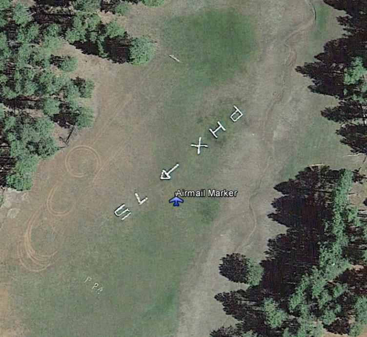
There are some very early ones out there. There is one that predates the light towers and was surveyed by Charles Lindbergh on the Mogollon Rim above Payson, AZ. I'm told there is another one in Mesa, AZ, but I've not found it. The one above Payson is maintained at a volunteer camp out every year. I would attach a Google Earth .kmz file of the location, but it doesn't seem possible to attach files here, so here's an image and coordinate. 34° 25.083'N 111° 24.522'W. Found the attachment button, but it declares Google Earth .kmz files as invalid and won't upload them.You should be able to paste the coordinate above into GE and go right too the marker.
Last edited by LarryAZ; 09-06-2013 at 01:34 PM.
This video of some guys who made a high-frequency replica of a Low Frequency ("four course") Range always intrigued me. Maybe we should set up an LFR approach in Oshkosh
https://www.youtube.com/watch?v=p-VqtNY8vpw
Tom Charpentier
Government Relations Director
EAA Lifetime #1082006 | Vintage #722921

I found the remains of an concrete arrow in NE Indiana which was part of the New York - Chicago airmail route. It was airway beacon No. 14 (Helmer). I've been trying to find evidence of the airmail route across northern Indiana.Originally Posted by dewi8095

Our rotating beacon at C62 was originally used on the airmail route (airway beacon No. 13) and then relocated the airport in the 1950's.
How did you go about finding it?
 Posting Permissions

 Reply With Quote